Jean Baptiste Point du Sable was the first non-native settler of Chicago. Du Sable set up a successful fur trading post which involved interaction between settlers and the indigenous Potawatomi tribe who hunted beaver. Du Sable built his home at the mouth of the Chicago river.
Prior to the canal's construction, nearly all of the city's sewage was pumped directly into the lake. This posed a problem once the water cribs were built because drinking water came from the lake through these water cribs. Fears of Typhoid and Cholera led the city to construct a massive drainage canal to divert sewage all the way to the Des Plaines River in order to preserve drinking water.
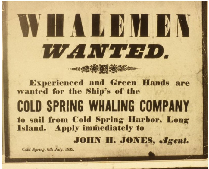
An act of incorporation, allowed the opening of the Cold Spring Harbor whaling company. This set up a thriving whaling industry in Cold Spring Harbor, that operated as the epicenter of the village's economy. This whaling period flourished in Cold Spring Harbor until 1862, when the last of the 9 whaling voyages that left from Cold Spring Harbor occurred.
In 1907, the John C. Walters' property was divided into 38 plots and 3 streets were laid out. These roads made transportation through the village easier, and the plots of lands had homes built on them and promoted migration to Cold Spring Harbor. This is the first subdivision of land in Cold Spring Harbor that is classified as suburbanization.
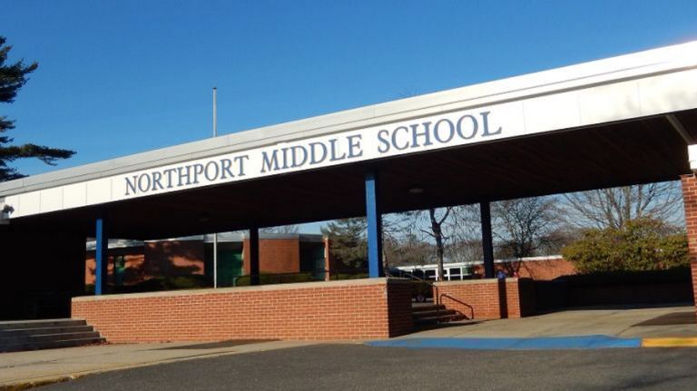
Due to high levels of mercury and other toxins in the waters, Northport Middle School was shut down. The Northport Power Station is suspect, however they claim that they have not found any evidence of toxins in the air. This is up for debate as to whether their claim can be given any weight, as they have in the past hidden their pollution of the environment from the public.
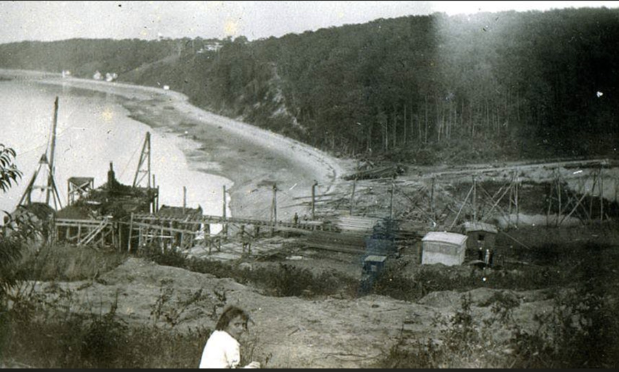
Steers and Steers Gravel Company was contracted to mine gravel in Northport. This gravel was to be used for construction in New York City. Due to the mining going unchecked for years, a large depression was carved into the land. The mining only ceased once the residents became unhappy with how expansive the depression had become.
In 1895, the Blackfeet Indigenous Tribe sold the western part of their land to the United State Government for 1.5 Million dollars. This is the land we now know today as Glacier National Park. In addition to monetary settlement the Blackfeet were also supposed to be able to hunt, fish and cut down timber for domestic purposes to sustain their tribe. This part of the agreement was no longer honored by the US government when the park was established in 1910, as the land was no longer considered public. This was a huge blow to the success of the tribe, and still deeply effects them today. Since the creation of the park the Blackfeet have made numerous claims to the Government asking for the rights to hunt and fish on the land that is theirs. To date, the only change that has been made is that Indigenous peoples do not need to pay to enter the park.
The decline of shipbuilding brought the increase of a number of minor industries. The biggest of these two were rubber and cordwood, which obviously had a number of environmental tolls. The rubber factory was placed on the shore and likely dumped in the Long Island Sound. The cordwood demand brought local deforestation and was aided by rail road expansion, which allowed more would to be brought in. This period of random industry died out in favor of wealthier suburbia by the early 1900s.
In the late 1800s the rail road would expand to eastern long island and connect locations like the Three Village area to New York City. This facilitated increased industrialization and then later increased suburbanization of the area. It also required the flattening of land, especially close to the hilly North Shore.
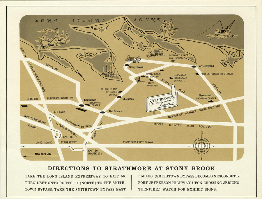
After the success of Levittown, Levitt and Sons, Inc. began looking for other places to construct planned communities. The Strathmore was one of these smaller planned communities, which they built in Stony Brook because they saw the growing popularity of suburbanization in the area. This likely brought mush of the same environmental toll that the original Levittown brought.
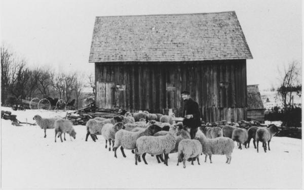
This photo is from the early 20th century, but reflects the dominant role that sheep played in Vermont in the 1830s and 1840s, when there were over one million sheep in the state.
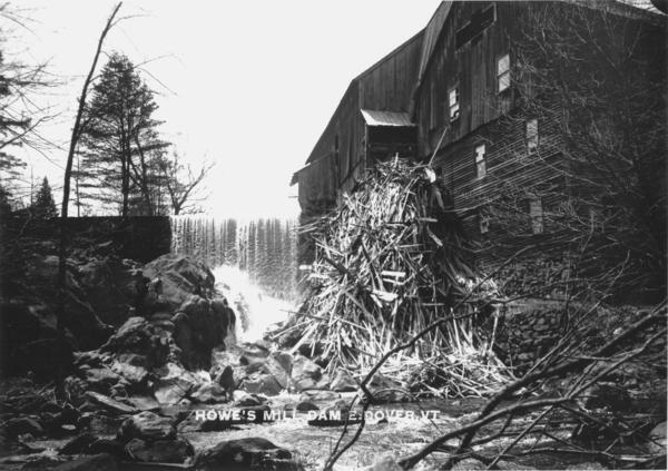
A sawmill operated on this site on the falls of the Rock River since 1792, and was the origins of the settlement of East Dover. This water-powered mill cut timber for construction, and also boards for tubs and for chairs, up until it burned in 1936. At that time it was the only "industry" in the town, employing 12 men.
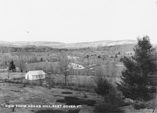
Compare the picture to the satellite view on the map below; the fields in the foreground and background have been abandoned, for the most part, and the forest that had been cleared has regrown. The building in the foreground was a one-room schoolhouse.
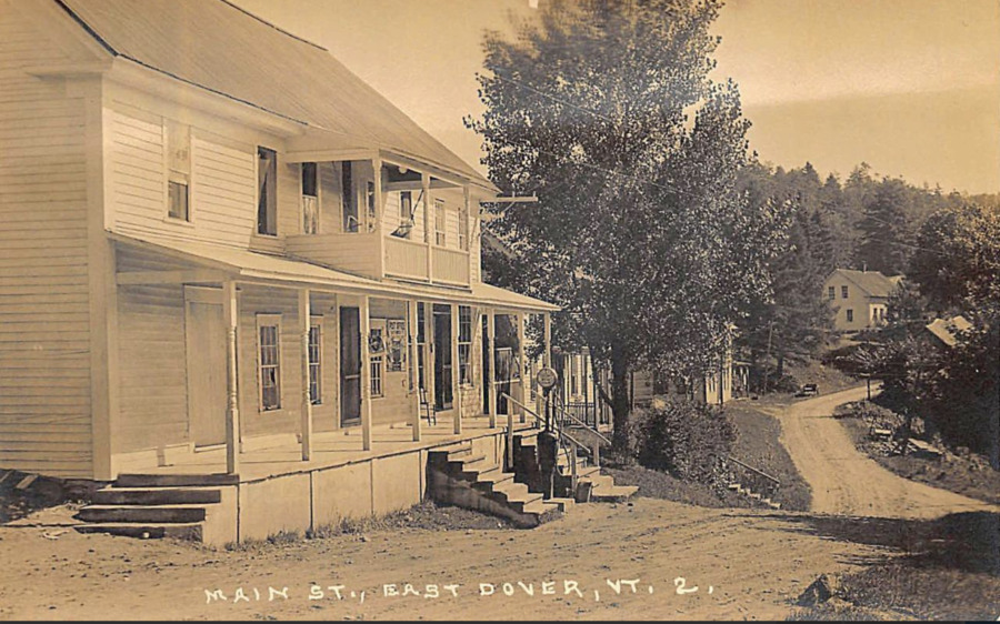
This is the center of town in East Dover, Vermont, most likely in the 1920s. Up until the late 1940s, there were no paved roads in the town, which produced nearly impassable roads in the spring "mud season" when frozen roads thawed. As the gasoline pump indicates, cars and trucks were in increasingly wide use. The post office is still in this building nearly a century later.
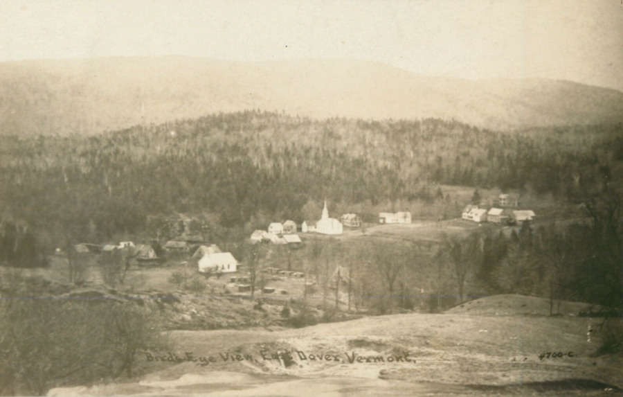
East Dover in the 1920s consisted of a small village with two sawmills, surrounded by small farms, though the dwindling population had led to some reforestation.
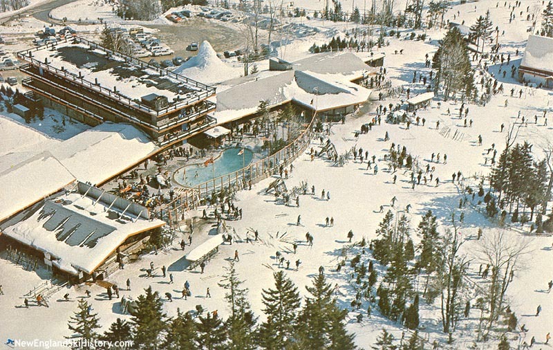
The opening of Mount Snow in 1954 transformed the western half of Dover from a farm town in decline to a bustling tourist destination. The mountain was part of the post-World War Two boom in skiing, which itself was part of a larger interest in outdoor recreation in the period. In the 1970s, when the author of this post started skiing there, it still featured an outdoor heated swimming pool that was open in the winter -- something that was closed in the late 1970s thanks to the energy crisis.
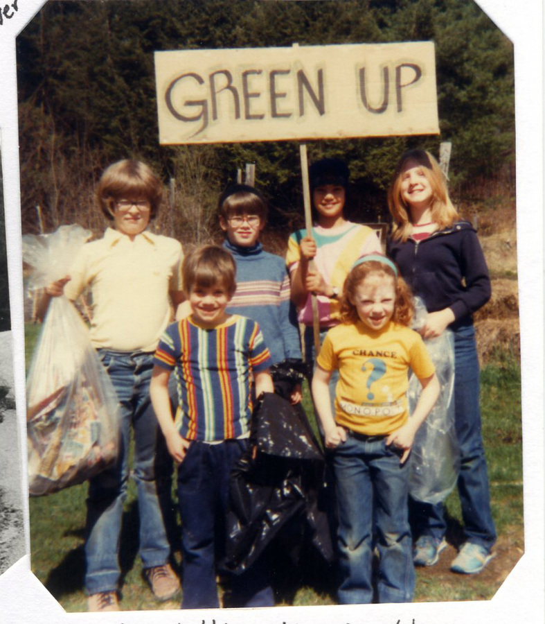
"Green Up" Day in Vermont was conceived in 1969 in the context of concern over litter along the state's roadsides. The first Green Up Day was held in 1970, four days before the inaugural Earth Day gatherings. This photo is from the late 1970s; the person with the trash bag on the left in the picture is somebody you know (imagine taller, better haircut, with a mask).
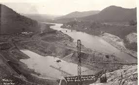
The Conklingville Dam was finalized in 1930 after decades of pressure by Cities downriver to create a reservoir for flood control and water storage purposes. The Dam flooded the Sacandaga River Valley, forcing all communities within the flood zone to relocate. Little say and notice was given to the local communities, leaving many families feeling blindsided and neglecte by the State.
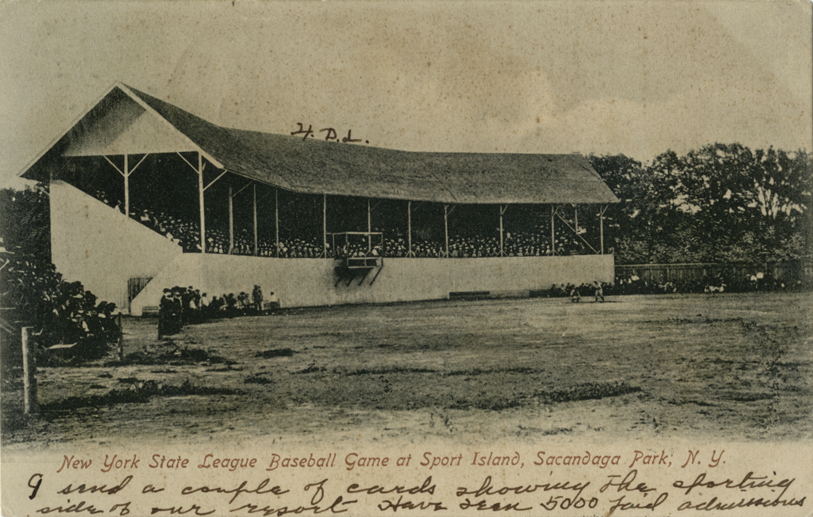
The Sacandaga Park was owned by the FGJ Railroad Company from 1881 until the creation of the Reservoir. The Park transformed from a getaway for urban elites, to an all-around wilderness amusement park, including Sports Island were baseball, boxing, and open-air spectacles were put on. The island was connected to the park via a walking bridge and miniature train.
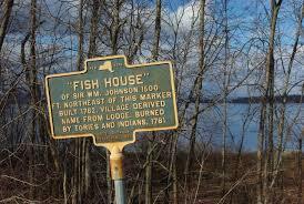
In 1762 Sir William Johnson opened up the Sacandaga River Valley to colonial settlement when he had created a road from his home Fort Johnson to the valley in order to facilitate trade with the Native Americans in the area, as well as have a place of leisure for himself. The Fish House Lodge was created in the same year, and became Johnsons place fo refuge to hunt in fish in the river valley abundant with game and fish. The lodge drew other colonist to the valley and Fish House, formerly known as North Hampton, became the first colonial settlement in the valley. The original lodge is believed to have burnt down in 1781 as a result of the Johnsons families loyalty to the Crown during the Revolutionary War.
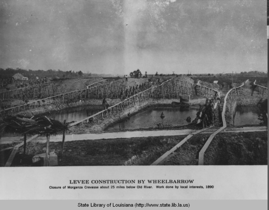
In the late 19th century the levee's were in slight disrepair due to time and in part also due to the civil war that had gone on a few decades prior. As the cheap labor that had been available was no longer since slavery was abolished. When i came time for the levee to be worked on the new cheapest labor was that of prisoners. The levee's were built in the 1700's when the founder of the city came along and have been needed to protect the city from floods coming form the gulf as well as from the Mississippi river.
Due to soil erosion and rising sea levels the improved barriers that had been placed around New Orleans will no longer be up to par. As sea levels rise, not only will many of the marshlands be effected but the barrier islands that have been acting as protection as stated by the article.
A radical transportation change took place in 1889, with the opening of the electric Marlborough Street Railway line, the second of its kind in the country. It initially ran a 2.5-mile route through Marlborough before being extended in 1890. In 1895, it was linked to Hudson and Northborough (adjacent towns), making it possible for passengers to ride the streetcar all the way to Boston or Worcester. In 1903, the Marlborough line was taken over by the Boston & Worcester Railway Company.
Until this year, the largest refinery on the East Coast was located on the banks of the Schuylkill river in South Philadelphia. Open since the 1860s, its ownership has changed hands many times over the last 150 years, but it was owned most recently by Philadelphia Energy Solutions. The refinery has been responsible for numerous fires in the past couple centuries, and especially in the 1800s, oil would cover the surface of the Schuykill river, causing it to regularly catch fire (and often take boats and people with it). Today, people living in the surrounding neighborhoods of Southwest Philly and Grays Ferry have higher rates of asthma and cancer than in other parts of the city due to the release of toxic chemicals by the refinery. Both these neighborhoods are predominantly Black, and 31.6% of Southwest and 41.3% of Grays Ferry residents live beneath the poverty line. On June 21st, 2019, the refinery caught fire once again, this time causing an explosion so large it could be seen from space. Debris from the explosion narrowly missed a tank containing hydrofluoric acid, a reagent used in the refining process. Had this tank been punctured, the acid would have vaporized, causing a cloud of toxic gas to descend over the city. An estimated 1.1 million people would need to be evacuated. However, it's likely that the evacuation would've been unsuccessful, given that the explosion occurred at 4am, and the shelter-in-place sirens didn't go off until 5:30am. If that tank had been punctured, it could've become the deadliest industrial disaster in history, killing thousands (if not tens of thousands) through inhalation of HF gas and leaching into the Schuylkill, a major water supply in the region. There are much safer alternatives to hydrofluoric acid, but none of these were used at the refinery because they're more expensive. This year, the refinery was permanently closed, and sold to a developer.